
Research Library
Browse books, articles, expedition reports, maps, images, archival documents, interviews, scientific papers, and primary sources related to the search for Noah’s Ark.
Collections
Build the Case From Sources

Primary Sources
Ancient texts, expedition notes, first-person accounts, interviews, field reports, original photographs and historical maps.
Scientific Research
Geology, geomorphology, geophysics, dating studies, materials testing, remote sensing and engineering analysis.
Historical Studies
Research on place-name traditions, Armenian geography, Mesopotamian history, pilgrimage and the development of Ark identification.
Expedition Archive
Team rosters, permits, objectives, routes, equipment, photos, outcomes and published interpretations.
Media & Imagery
Aerial photographs, satellite scenes, field photography, maps, diagrams, GPR plots, drill logs and photogrammetry.
Critical Assessments
Contrary geological interpretations, failed replication, provenance problems and evidence that argues against a claim.
Card Catalog / Interactive
Search the Working Archive
This is the beginning of the ArkSearch source catalog. Search by person, place, method, date, or subject, then narrow the results by source class. As the archive grows, these records can be migrated directly into a dedicated ArkSearch database.
ArkSearch uses a Chicago/SBL-oriented source display: author or responsible institution, work or record title, publication/archive, date and stable locator are retained when the source provides them. Missing bibliographic information is not silently reconstructed. Each library item also carries a stable ArkSearch record ID so a reader can cite the catalog entry while still following the original source.
Gertrude Bell — Cudi Dagh diary
Bell’s May 1909 field diary records her travel on Cudi Dagh and provides contemporary context for her photographs of the summit landscape.
Cite this ArkSearch record
ArkSearch, “Gertrude Bell — Cudi Dagh diary,” Research Library, record AS-001, last reviewed October 31, 2026.
Cudi summit ruins — Bell photograph
A public-domain field photograph by Gertrude Bell showing ruins on the summit of Cudi Dagh.
Cite this ArkSearch record
ArkSearch, “Cudi summit ruins — Bell photograph,” Research Library, record AS-002, last reviewed October 31, 2026.
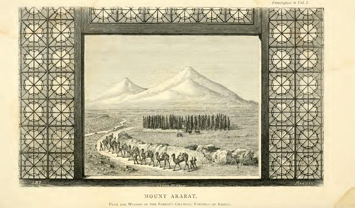
Telfer — Mount Ararat illustration
Public-domain nineteenth-century travel illustration from John Buchan Telfer’s The Crimea and Transcaucasia.
Cite this ArkSearch record
ArkSearch, “Telfer — Mount Ararat illustration,” Research Library, record AS-003, last reviewed October 31, 2026.
James Bryce — Ararat ascent
Bryce’s ascent and reported high-altitude timber find became a frequently repeated episode in later Ark literature.
Cite this ArkSearch record
ArkSearch, “James Bryce — Ararat ascent,” Research Library, record AS-004, last reviewed October 31, 2026.
Qur’an 11:44 — al-Jūdī
The Qur’anic Flood account states that the vessel came to rest upon al-Jūdī.
Cite this ArkSearch record
ArkSearch, “Qur’an 11:44 — al-Jūdī,” Research Library, record AS-005, last reviewed October 31, 2026.
Josephus — Ark traditions
Josephus preserves earlier reports concerning the Ark’s resting region and alleged surviving remains.
Cite this ArkSearch record
ArkSearch, “Josephus — Ark traditions,” Research Library, record AS-006, last reviewed October 31, 2026.
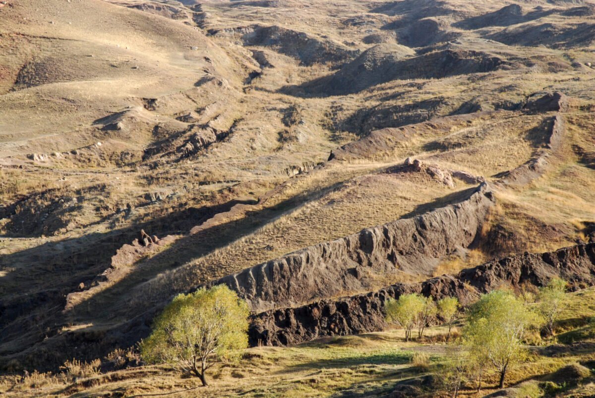
Durupınar — current geophysics & drilling
Current work combines geophysical surveys, sampling, and drilling to test interpretations of subsurface anomalies.
Cite this ArkSearch record
ArkSearch, “Durupınar — current geophysics & drilling,” Research Library, record AS-007, last reviewed October 31, 2026.
Collins & Fasold — geological reassessment
Lorence Collins and former Durupınar advocate David Fasold interpret the formation as a natural geologic structure and test several specific artifact claims.
Cite this ArkSearch record
ArkSearch, “Collins & Fasold — geological reassessment,” Research Library, record AS-008A, last reviewed October 31, 2026.
Avcı — Telçeker earthflow model
Murat Avcı models the ship-like feature as a resistant Miocene limestone block displaced over weaker clay and reshaped by mass movement, abrasion and dissolution.
Cite this ArkSearch record
ArkSearch, “Avcı — Telçeker earthflow model,” Research Library, record AS-008B, last reviewed October 31, 2026.
İlhan Durupınar — official aerial discovery record
Turkey’s General Directorate of Mapping records Durupınar noticing the formation on September 11, 1959 and reproduces the early aerial image and contemporary newspaper report.
Cite this ArkSearch record
ArkSearch, “İlhan Durupınar — official aerial discovery record,” Research Library, record AS-009, last reviewed October 31, 2026.
LIFE — first ground expedition
The September 5, 1960 issue documents the first expedition and the negative archaeological result that temporarily ended interest in the formation.
Cite this ArkSearch record
ArkSearch, “LIFE — first ground expedition,” Research Library, record AS-009B, last reviewed October 31, 2026.
Aerial & satellite reconnaissance
Repeated imagery can relocate features, compare seasonal exposure, and test whether claimed anomalies persist through time and viewpoint.
Cite this ArkSearch record
ArkSearch, “Aerial & satellite reconnaissance,” Research Library, record AS-010, last reviewed October 31, 2026.
Sivas Cumhuriyet University — 2026 project
The university’s project notice documents the authorized 2026 field program under Prof. Dr. Cenker Atila, including mapping, GPR, soil sampling and core recovery.
Cite this ArkSearch record
ArkSearch, “Sivas Cumhuriyet University — 2026 project,” Research Library, record AS-011, last reviewed October 31, 2026.
Reassessing the Durupınar Formation
A 2026 critical evaluation of recent geophysical, geochemical, geological and archaeological claims, emphasizing where new drilling can test earlier interpretations.
Cite this ArkSearch record
ArkSearch, “Reassessing the Durupınar Formation,” Research Library, record AS-012, last reviewed October 31, 2026.
Jubilees — Mount Lubar
Jubilees names Lubar as the mountain where the Ark rested and places it among the mountains of Ararat.
Cite this ArkSearch record
ArkSearch, “Jubilees — Mount Lubar,” Research Library, record AS-013, last reviewed October 31, 2026.
Nicolaus of Damascus — Mount Baris
Josephus preserves Nicolaus’s account of a great mountain called Baris above Minyas in Armenia where a flood survivor in an ark came ashore.
Cite this ArkSearch record
ArkSearch, “Nicolaus of Damascus — Mount Baris,” Research Library, record AS-014, last reviewed October 31, 2026.
Gilgamesh — Nimuš / Nisir
Tablet XI gives Utnapishtim’s vessel a named landing mountain in the Babylonian Flood tradition.
Cite this ArkSearch record
ArkSearch, “Gilgamesh — Nimuš / Nisir,” Research Library, record AS-015, last reviewed October 31, 2026.
Apamea Kibotos — Noah coin tradition
Roman provincial coinage and the site’s later historical record preserve a localized Noah-and-Ark tradition in Phrygia.
Cite this ArkSearch record
ArkSearch, “Apamea Kibotos — Noah coin tradition,” Research Library, record AS-016, last reviewed October 31, 2026.
Nakhchivan — Noah tomb & descent traditions
Nineteenth-century records document a local Noah tomb shrine while historical linguistics cautions against treating popular “first descent” etymologies as established fact.
Cite this ArkSearch record
ArkSearch, “Nakhchivan — Noah tomb & descent traditions,” Research Library, record AS-017, last reviewed October 31, 2026.
UNESCO — Gamigaya “ship-rock” tradition
Azerbaijan’s 2024 tentative-list submission records local folklore that Ark remains were preserved at Gamigaya.
Cite this ArkSearch record
ArkSearch, “UNESCO — Gamigaya “ship-rock” tradition,” Research Library, record AS-018, last reviewed October 31, 2026.
Sabalan → Takht-e Suleiman Ark proposals
Bob Cornuke’s Iran search shifted from Sabalan to the Alborz/Takht-e Suleiman region, producing one of the best-documented modern alternative-site sequences.
Cite this ArkSearch record
ArkSearch, “Sabalan → Takht-e Suleiman Ark proposals,” Research Library, record AS-019, last reviewed October 31, 2026.
Babylonian Map of the World — “Ark directions” claim
BM 92687 genuinely names Urartu and preserves fragmentary mythic geography; a 2024 interpretation links a damaged passage to Flood-vessel terminology.
Cite this ArkSearch record
ArkSearch, “Babylonian Map of the World — “Ark directions” claim,” Research Library, record AS-020, last reviewed October 31, 2026.
Humphreys — western Zagros / Zard Kuh
A creationist biblical-geography argument placing the likely Ark region east of southern Iraq and naming Zard Kuh as one possible peak.
Cite this ArkSearch record
ArkSearch, “Humphreys — western Zagros / Zard Kuh,” Research Library, record AS-021, last reviewed October 31, 2026.
Clarey — Ark landed west of Ararat
Tim Clarey proposes Kağızman Ridge as the landing region based on ICR’s Flood-stratigraphic model and a post-Flood age for modern Mount Ararat.
Cite this ArkSearch record
ArkSearch, “Clarey — Ark landed west of Ararat,” Research Library, record AS-022, last reviewed October 31, 2026.
Philostorgius — singular “Mount Ararat” tradition
Philostorgius describes a Mount Ararat in Armenia as the mountain on which Scripture says the Ark rested and reports surviving wood and nails.
Cite this ArkSearch record
ArkSearch, “Philostorgius — singular “Mount Ararat” tradition,” Research Library, record AS-023, last reviewed October 31, 2026.
William of Rubruck — Massis and the Ark
Rubruck describes two mountains called Massis, the Araxes below them, and the Ark tradition attached to the greater peak.
Cite this ArkSearch record
ArkSearch, “William of Rubruck — Massis and the Ark,” Research Library, record AS-024, last reviewed October 31, 2026.
H. F. B. Lynch — Ararat ascent record
Lynch preserves a useful synthesis of successful Mount Ararat ascents and their approach routes, including St. Jacob/Akhury, Sardar Bulakh and Bayazid.
Cite this ArkSearch record
ArkSearch, “H. F. B. Lynch — Ararat ascent record,” Research Library, record AS-025, last reviewed October 31, 2026.
Le Monde — French Ararat expedition
Contemporary reporting on the de Riquer–Navarra expedition records a serious glacier search and a negative identification of the aerial “hull” target.
Cite this ArkSearch record
ArkSearch, “Le Monde — French Ararat expedition,” Research Library, record AS-026, last reviewed October 31, 2026.
ArcImaging — Mount Ararat Archaeological Survey
A field-survey report documenting archaeological-search work on Mount Ararat and the methods used to investigate proposed Ark-related targets.
Cite this ArkSearch record
ArkSearch, “ArcImaging — Mount Ararat Archaeological Survey,” Research Library, record AS-027, last reviewed October 31, 2026.
Noah’s Ark Scans — modern survey reports
The project archive collects modern Durupınar GPR, ERT, LiDAR, photogrammetry and related survey reports used in current architectural interpretations.
Cite this ArkSearch record
ArkSearch, “Noah’s Ark Scans — modern survey reports,” Research Library, record AS-028, last reviewed October 31, 2026.
Targum Onkelos — Genesis 8:4 / Qardu
Onkelos renders the Hebrew “mountains of Ararat” with the mountains of Qardu/Kardu.
Cite this ArkSearch record
ArkSearch, “Targum Onkelos — Genesis 8:4 / Qardu,” Research Library, record AS-029, last reviewed October 31, 2026.
Syriac biblical tradition — Qardu
The Syriac biblical and interpretive tradition preserves Qardu in the Ark’s landing geography, with later Syriac resources also recording the Noah monastery tradition east of Gazarta/Cizre.
Cite this ArkSearch record
ArkSearch, “Syriac biblical tradition — Qardu,” Research Library, record AS-030, last reviewed October 31, 2026.
Sennacherib 222 — Cudi Dagh / Mount Nipur
The RINAP edition of Sennacherib’s fifth-campaign inscription anchors Assyrian royal activity on the Cudi Dagh / Mount Nipur landscape.
Cite this ArkSearch record
ArkSearch, “Sennacherib 222 — Cudi Dagh / Mount Nipur,” Research Library, record AS-031, last reviewed October 31, 2026.
Friedrich Bender — Cudi field investigation
Bender climbed Cudi in 1953 and recovered decayed, asphalt-associated material from the traditional site; later radiocarbon reporting became part of the modern Cudi evidence discussion.
Cite this ArkSearch record
ArkSearch, “Friedrich Bender — Cudi field investigation,” Research Library, record AS-032, last reviewed October 31, 2026.
International Noah and Cudi Mountain Symposium
The Şırnak symposium program documents the modern research gathering that brought Ark-history and Cudi researchers together in the region.
Cite this ArkSearch record
ArkSearch, “International Noah and Cudi Mountain Symposium,” Research Library, record AS-033, last reviewed October 31, 2026.
Nate Loper — Cudi Dagh 3D terrain model
A 3D terrain model of the traditional Cudi Dagh Ark-site landscape prepared for spatial orientation, research communication and teaching.
Cite this ArkSearch record
ArkSearch, “Nate Loper — Cudi Dagh 3D terrain model,” Research Library, record AS-034, last reviewed October 31, 2026.
Sources & Documentation
Trace the Claims to Their Sources
Use the library to move from a claim or historical account to the books, articles, images, interviews, field reports, maps, and other records behind it.