
Cudi Dagh
Cudi Dağı in southeastern Turkey preserves one of the oldest and most persistent regional traditions associated with the Ark’s landing, distinct from the modern Mount Ararat search tradition.
The case
The Older Geographic Tradition?
In this dossier
Cudi Dagh belongs to a very different evidentiary category from a modern radar anomaly or alleged timber sample. Its importance is historical: a longstanding regional memory connecting Noah’s Ark with the mountains south of the Armenian highlands and north of Mesopotamia.
Texts before topography
The central research task is to trace when particular place names appear, what geographic region ancient and medieval writers meant, and whether later translations silently replace a broad or different location with “Ararat.” ArkSearch preserves original terms wherever possible.
Field questions
What pilgrimage sites or ruins were historically associated with Noah? Which reports claim surviving remains, and how early are the surviving sources? Can specific mountains, monasteries or local place names be securely mapped? What modern fieldwork has actually tested those locations?
Explorer’s archive
Gertrude Bell on Cudi Dagh
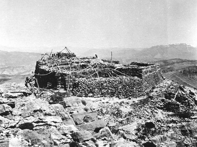
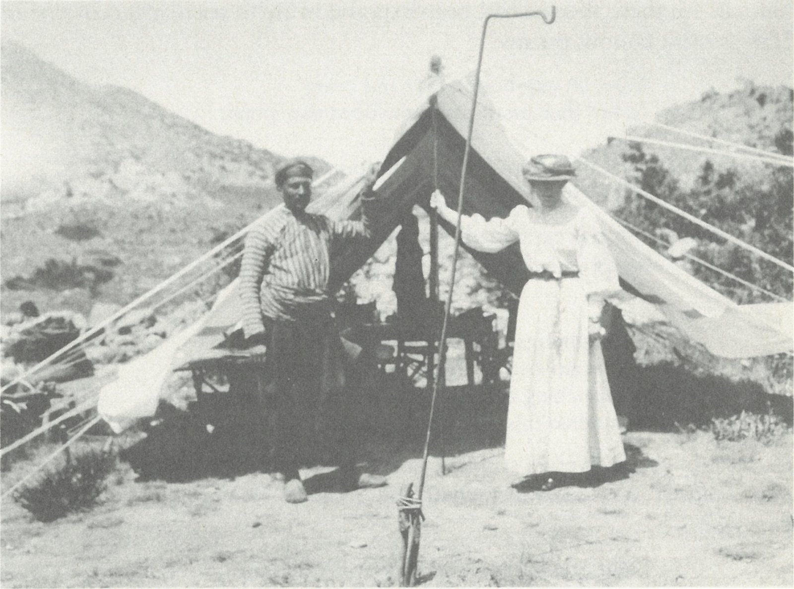
In May 1909, explorer and photographer Gertrude Bell traveled on Cudi Dagh, recorded the journey in her diary, and photographed ruins on the summit associated by local tradition with Noah. The photographs give ArkSearch something unusually valuable: a genuine expedition-era visual record of the landscape rather than a later reconstruction.
This material belongs in both the historical and fieldwork dossiers. It documents what was present and being identified locally in the early twentieth century, while leaving the archaeological interpretation open.
Case Evolution / Cudi Dağı
From Qardu to Cudi Dagh
Cudi’s historical case is not built on one late identification. It is a chain of overlapping geographic names—Corduene, Kardu/Qardu, Korduk‘ and al-Jūdī—centered on the upper Tigris and Cizre region. The task is to show where those names genuinely overlap and where later interpretation goes beyond the sources.
Berossus: the Cordyaean mountain
Josephus preserves Berossus’s statement that remains of the flood vessel were still said to exist in Armenia “at the mountain of the Cordyaeans.” This is the earliest surviving reasonably explicit literary witness to an Ark-remains tradition in the Cudi/Qardu region, though it does not name the modern summit.
Ararat becomes Qardu in translation
Targum Onkelos renders Genesis 8:4 as the mountains of Qardu/Kardu rather than retaining Ararat. The Syriac Peshitta likewise uses Qardu, and Ephrem the Syrian explicitly says the Ark rested on Mount Qardu.
Christian pilgrimage geography develops
Epiphanius locates Mount Lubar in the Ararat mountains between Armenians and Kardyaioi, while the Armenian history attributed to P‘awstos places Jacob of Nisibis’ Ark pilgrimage on Sararad in Korduk‘. Syriac traditions attach an Ark sanctuary and pilgrimage memory to Qardu.
al-Jūdī becomes explicit
Qur’an 11:44 names al-Jūdī directly as the mountain on which the Ark came to rest. Early Islamic interpretation places it in the Jazira/Mosul world, and medieval geographers increasingly tie the tradition to the Cizre–Cudi landscape.
Pilgrimage and sanctuary memory persist
Christian and Muslim traditions remember a sanctuary, feast, relics, Noah associations and nearby post-Flood settlement traditions such as Thamanin. Those memories need source-by-source dating rather than being treated as one uninterrupted eyewitness chain.
The tradition enters modern field documentation
Gertrude Bell photographed and described the summit ruins in 1909. Friedrich Bender sampled material in 1953. Later researchers, symposia, satellite work, 3D terrain models and renewed field visits have made Cudi a modern research landscape as well as an inherited sacred one.
Document Test / Earliest Tradition
How Early Is the Cudi Tradition?
The strongest historical argument for Cudi is cumulative. No single ancient author gives modern coordinates, but multiple Jewish, Christian and later Islamic traditions converge on Qardu/Corduene and eventually on al-Jūdī.
Berossus
The Babylonian priest Berossus is quoted as saying that part of the flood vessel remained “at the mountain of the Cordyaeans,” where people removed bitumen as amulets. This is a regional Corduene witness—not yet proof of the specific modern summit.
Mountains of Qardu
Onkelos translates Genesis 8:4 with the mountains of Qardu. That is important because it shows a Jewish interpretive geography locating biblical Ararat in the Qardu region rather than on the later European “Mount Ararat.” The final dating of Targumic textual forms remains debated.
Peshitta & Ephrem
The Syriac biblical tradition also substitutes Qardu for Ararat in Genesis 8:4. In the fourth century, Ephrem the Syrian states that the Ark came to rest on Mount Qardu—especially notable because his world was centered at Nisibis, west of Cudi.
Jacob, Korduk‘ & Lubar
P‘awstos places Jacob of Nisibis’ ascent to see the Ark on Sararad in the district of Korduk‘. Epiphanius puts Mount Lubar between Armenians and Kardyaioi. Neither should be simplified into a modern GPS pin, but both reinforce the southern Ararat/Qardu geography.
al-Jūdī by name
The Qur’an provides the first scriptural text in this chain to name al-Jūdī itself. Al-Ṭabarī describes it as a mountain in the region of Mosul or the Jazira, helping anchor later Islamic geography in upper Mesopotamia.
Cizre, Qardu & Thamanin
Yāqūt attests al-Jūdī in his geographical dictionary, Syriac sources remember the Ark monastery on Mount Qardu, and Ibn al-Athīr places Noah’s post-Flood settlement in Karda in the Jazira. These texts strengthen the identification of the tradition with the Cizre–Cudi region.
Field Geography / Mountain Record
Who Was Actually on Cudi?
Unlike many Ark-location arguments, Cudi has both a literary tradition and a traceable human history on the mountain itself—from Assyrian royal inscriptions to pilgrimage ruins and modern field visits.
Sennacherib on Mount Nipur
Sennacherib’s fifth-campaign inscriptions were carved on Cudi Dagh itself. The RINAP corpus identifies the rock-face text as the “Judi Dagh Inscription” and connects it to Mount Nipur. This securely places the Assyrian king on the mountain; the inscriptions say nothing about Noah’s Ark.
Primary Assyrian record
Jacob of Nisibis & the Ark pilgrimage
Christian narratives remember Jacob seeking the Ark in Korduk‘/Qardu and receiving a relic. The exact development of the monastery tradition must be dated carefully, but it shows that Christian sacred geography had attached an Ark pilgrimage to this southern region long before modern exploration.
Pilgrimage tradition
Monastery of the Ark
Syriac geographic records preserve a monastery of Mar Nuḥ / the Ark on Mount Qardu. Muslim writers likewise describe al-Jūdī, Noah traditions and nearby settlements. This is evidence for sustained sacred use even where individual structures are difficult to date.
Sanctuary memory
Gertrude Bell reaches the site
Bell’s diary records her climb of Cudi Dagh and her photographs identify the ruins as the reputed resting place of Noah’s Ark. Her images provide a rare visual baseline for the summit complex before modern reconstruction and tourism.
Primary field photography
Friedrich Bender samples the summit area
Bender reported recovering asphalt-bound decayed wood from the traditional landing area. Later radiocarbon work yielded an age around 6,500 years before present. The sample is historically important, but its exact archaeological context and identification as Ark material remain unresolved.
Material claim
Renewed field research
Bill Crouse and Gordon Franz conducted field visits; the 2013 International Noah and Cudi Mountain Symposium brought researchers to Şırnak; Stephen Compton reached the summit and documented ruins, chambers and the traditional site with modern photography and satellite comparison.
Modern documentation
Thamanin and regional archaeology
The second international Cudi symposium included Stephen Compton’s work on locating Thamanin and studies of Cudi in cuneiform sources. Researchers continued field visits in 2025, tying textual geography to candidate archaeological sites around the Cizre plain.
Regional research
The Cudi case remains active
Cudi featured again in 2026 scholarship and conference work, including the ISMANA meeting at Ağrı. Nate Loper’s 2026 Digging for Truth appearance also presented Cudi as the older historical candidate compared with current Durupınar headlines.
Current research
Evidence History / Claims Ledger
Tradition, Artifact, or Interpretation?
Cudi has unusually deep historical tradition, but that does not turn every later claim into archaeology. The ledger keeps the strongest observations separate from the conclusions placed on them.
| Date | Claim / record | Assessment |
|---|---|---|
| c. 697 BC | Sennacherib’s Mount Nipur campaign. Royal inscriptions and relief panels survive on Cudi Dagh. | Direct evidence that Sennacherib operated on the mountain. The cuneiform texts do not mention Noah or Ark remains. Documented primary evidence |
| Late antique | Jacob of Nisibis relic tradition. Christian narratives say Jacob sought the Ark and received a plank or relic. | Important evidence for an old pilgrimage tradition in Qardu/Korduk‘; not an independently proven surviving Ark fragment. Tradition with geographic value |
| Rabbinic | Sennacherib and the Ark plank. Sanhedrin 96a tells of Sennacherib finding a plank from Noah’s Ark and worshiping it. | The rabbinic story does not name Cudi. Linking it to Cudi is an inference made stronger by the independent Assyrian evidence that Sennacherib was on Mount Nipur/Cudi. Later tradition / plausible geographic link |
| 1909 | Bell’s summit ruins. Gertrude Bell photographed the traditional landing-place complex and associated monastery remains. | The photographs securely document structures and living local tradition. They do not demonstrate that any ruin or object is part of the Ark. Documented field record |
| 1953–1970s | Bender wood and asphalt claim. Friedrich Bender recovered decayed material from beneath sediment at the traditional site; later testing reportedly returned an age around 6,500 years. | A real material-testing episode, but chain of custody, precise context, species identification and connection to a vessel remain insufficient for archaeological identification. Tested material / unresolved provenance |
| 2013–present | Summit structures and “Ark-site” landform. Modern photography, satellite imagery and field visits document ruins, depressions, walls and terrain. | Useful for mapping and repeatable observation. Identifying particular shapes or structures as Ark-related requires controlled archaeological excavation and dating. Interpretation not established |
| 2021–2026 | Thamanin and Cizre-plain localization. Researchers have attempted to connect medieval “Village of the Eighty” traditions to archaeological sites around Cudi. | A promising historical-geography problem; candidate sites require excavation and chronological control before identification can be secure. Active research question |
Researcher File / Nate Loper
Mapping and Teaching the Cudi Case
Nate Loper has publicly argued for Cudi Dagh as the strongest candidate for the Ark’s landing place, emphasizing the “mountains of Ararat” as a regional expression and the older Jewish, Christian and Islamic Cudi/Qardu tradition over the later identification with modern Ağrı Dağı.
Cudi Dagh Traditional Ark Site
Preview from Nate Loper’s 2020 3D terrain model. The interactive viewer is hosted on Sketchfab.
Cudi Dagh 3D Model
Loper published the interactive terrain model in October 2020 to make the traditional site, summit ruins and surrounding topography easier to study spatially. The model is distributed under a Creative Commons Attribution license and has also been linked directly by the Digging for Truth podcast.
His published model description states his position plainly: the longstanding traditional Ark site is Cudi rather than the modern mountain commonly called Ararat, and he connects that conclusion with Jewish, Christian and Islamic historical traditions.
The Nipur–Nisroch Question
Loper has explored whether the later rabbinic story of Sennacherib worshiping a plank from Noah’s Ark could preserve memory connected with the king’s documented campaign on Mount Nipur/Cudi. ArkSearch presents this as a historical hypothesis: the Assyrian campaign is primary evidence; the Ark-plank identification is later tradition.
Why Loper Favors Cudi
Across the 3D model and Digging for Truth appearances, Loper’s case centers on historical geography: Genesis says “mountains of Ararat”; Cudi lies at the northern edge of Mesopotamia within the wider Ararat/Urartu highland world; and Qardu/Corduene/Cudi preserves a much older documented landing tradition than modern Ağrı Dağı.
This is Loper’s research conclusion, not an ArkSearch declaration that the archaeological identification is proven.
Personnel File / Cudi Dağı
People in the Cudi Research
Cudi’s modern research history combines primary field observers, geologists, historians, archaeologically oriented researchers, photographers and educators. Inclusion records contribution and position; it does not mean ArkSearch endorses every interpretation.
Open full personnel ledgerField observers, historians, and researchers
Gertrude Bell
Open field note
Bell climbed Cudi Dagh in May 1909, recorded the route in her diary and photographed the summit complex known locally as the resting place of Noah’s Ark. Her archive is one of the strongest early visual records of the site.
Friedrich Bender
Open field note
Bender climbed Cudi in spring 1953 and recovered decayed, asphalt-associated material from the traditional site. Later radiocarbon results were reported at roughly 6,500 years before present. The sample history is important but does not establish Ark provenance.
Bill Crouse
Open field note
Crouse helped revive the historical case for Cudi in English-language Ark research, emphasizing Jewish, Christian and Islamic source continuity, regional geography and the weakness of the later Ağrı Dağı identification. He has also participated in field visits to the region.
Gordon Franz
Open field note
Franz visited the Cudi region with Bill Crouse in 2008 and later presented research at the 2013 Cudi symposium. His Sennacherib study explores whether the rabbinic Ark-plank story could be historically connected with the king’s documented campaign on Mount Nipur.
Stephen Compton
Open field note
Compton reached Cudi’s summit and has documented ruins, chambers, reliefs, satellite imagery and candidate sites around the Cizre plain. His 2021 symposium work focused on locating Thamanin, and he continued field research in the region in 2025.
Timo Roller
Open field note
Roller has participated in Cudi research since the 2013 symposium, published on pilgrimage history and Ibn al-Athīr, revisited the region in 2025 and presented Cudi as a possible Ark landing place at the 2026 ISMANA symposium.
Nate Loper
Open field note
Loper considers Cudi Dagh the strongest candidate for the Ark’s landing place on historical and geographic grounds. His public work emphasizes Genesis’s plural “mountains of Ararat,” the older Qardu/Corduene/Cudi tradition, Sennacherib’s documented presence on Mount Nipur and the contrast with the later modern-Ararat identification.
He published an interactive Cudi terrain model in 2020, discussed the site in the 2024 Digging for Truth podcast, and returned to the case in the 2026 television episode Did Noah’s Ark Land on This Mountain?
Summit Record
Open field note
The surviving Bell photograph documents physical ruins and the traditional summit complex as it appeared in 1909. The image is evidence for the site’s material history and pilgrimage memory, not proof that the ruins are Ark remains.
Archive Desk / Source Dossier
Documents Behind the Cudi Case
Cudi’s historical strength comes from multiple independent traditions converging on the Qardu/Corduene/Jazira landscape. ArkSearch works from the earliest recoverable text forward and keeps geographic evidence separate from later claims about surviving Ark material.
Open full source dossierAncient through modern documentation
Berossus via Josephus
Josephus quotes the Babylonian priest Berossus as saying that part of the flood vessel still existed in Armenia “at the mountain of the Cordyaeans,” where people removed bitumen as amulets. This is the earliest surviving regional Ark-remains testimony in the Cudi/Qardu dossier.
Targum Onkelos — Genesis 8:4
Onkelos renders the Hebrew “mountains of Ararat” as the mountains of Qardu/Kardu. The reading is a major Jewish witness to southern Ararat geography, even though the dating and stabilization of the Targumic text must be treated cautiously.
Peshitta, Ephrem & Qardu
The Syriac Bible replaces Ararat with Qardu in Genesis 8:4, and fourth-century Ephrem the Syrian says the Ark came to rest on Mount Qardu. Syriac geographic resources also preserve the Ark monastery tradition east of Gazarta/Cizre.
P‘awstos & Epiphanius
P‘awstos places Jacob of Nisibis’ Ark pilgrimage on Sararad in Korduk‘; Epiphanius locates Mount Lubar within Ararat between Armenians and Kardyaioi. These texts preserve southern geography while also showing that more than one mountain-name circulated.
Sennacherib’s Judi Dagh Inscription
The RINAP edition of Sennacherib’s fifth-campaign inscription identifies the rock-face texts on Cudi Dagh and Mount Nipur. The primary Assyrian evidence proves royal activity on this mountain but contains no Ark reference.
Qur’an and Islamic Geography
Qur’an 11:44 names al-Jūdī directly. Al-Ṭabarī places it in the region of Mosul or the Jazira; Yāqūt later attests al-Jūdī in his geographical dictionary. Ibn al-Athīr, writing from Cizre, places Noah’s post-Flood settlement in Karda in the Jazira.
Gertrude Bell Field Archive
Bell’s diary and photographs document her May 1909 visit to Cudi Dagh, including the summit ruins identified locally as the resting place of Noah’s Ark. The Newcastle archive preserves both the written route record and dated photographs.
Friedrich Bender Fieldwork
Bender’s published account states that he climbed Cudi in spring 1953 and recovered asphalt-associated decayed wood from the traditional landing site. Later radiocarbon work returned an age of roughly 6,500 years before present.
Modern Field Documentation
Stephen Compton’s summit record documents the traditional site, ruins and nearby terrain; the 2013 and 2021 Cudi symposia assembled historical and field research; later visits continued work on Thamanin, Assyrian reliefs and Cizre-plain geography.
Current Research & Public Scholarship
Cudi remained active in 2026 research and media: recent papers continue to compare Cudi and Ağrı Dağı; the ISMANA symposium included Cudi-focused work; and Nate Loper presented the older Cudi tradition in a new Digging for Truth episode.
ArkSearch Assessment
What the Cudi Case Can—and Cannot—Establish
Assessment
Cudi Dağı has the deepest continuous historical-geographic case among the major modern Ark candidates: Berossus’s Cordyaean mountain, Jewish and Syriac Qardu, late-antique Christian pilgrimage geography, Qur’anic al-Jūdī, medieval Cizre-area tradition, and modern field documentation all point into the same upper-Tigris world. That convergence is historically significant. It still does not amount to an archaeological identification of Noah’s Ark. The decisive next step is controlled excavation and dating of specific summit structures, candidate material contexts and nearby settlement sites such as those proposed for Thamanin.
Dossier Navigator / Interactive
Work the Case File
Move between the major evidence categories without losing the distinction between what is observed and what is inferred.
Trace Cudi before modern Ark hunting
Cudi’s strongest case is historical geography. The source chain now begins with Berossus’s Cordyaean mountain, then tracks Qardu in Jewish and Syriac texts, al-Jūdī in the Qur’an and Islamic geography, and the later Cizre-centered pilgrimage tradition without flattening those witnesses into one undifferentiated claim.
Map the names, not just the translations
Cudi Dağı sits within a landscape historically described through names such as Jazira, Kardu/Qardu and the Cizre region. The project will map those terms carefully rather than assuming that modern labels are interchangeable.
What did visitors believe they were seeing?
Reports of sacred sites, commemorations and alleged remains can preserve valuable historical memory even when they do not provide archaeological proof. The archive will distinguish ritual tradition from claimed physical observation.
What can still be tested?
Historical strength does not remove the need for field investigation. Bell’s summit ruins, Bender’s sampling area, Compton’s modern field documentation, the Assyrian reliefs and candidate Thamanin sites can all be mapped—but only controlled excavation, dating and provenance can turn a traditional identification into archaeological evidence.
Continue the Investigation
Follow the Cudi Case
Historical Accounts
Trace Josephus, al-Jūdī, medieval geography and Bell through their surviving source language.
→
Research Library
Open primary texts, historical imagery and archival records connected with Cudi.
→
Timeline
Place the Cudi tradition alongside Ararat and Durupınar without blending their histories.
→