
Mount Ararat
The towering volcanic massif that dominates the modern public imagination of Noah’s Ark—and the setting for more than a century of expeditions, sighting claims and searches.
The case
Why Ararat?
In this dossier
Mount Ararat became the dominant modern candidate for the Ark and has attracted climbers, missionaries, military personnel, filmmakers, scientists and independent expedition teams. Its scale, glaciers and political sensitivity have also made direct investigation difficult.
Historical & expedition record
The modern search includes published ascents, alleged high-altitude timber, reported sightings, aerial reconnaissance and attempts to locate anomalies in snow and ice. ArkSearch organizes these chronologically so later retellings can be checked against earlier records.
What would strengthen the case?
A find with precise coordinates, documented recovery, independent access, clear archaeological context and repeatable material analysis would be dramatically stronger than shape recognition, testimony alone or an object with uncertain provenance.
Key open questions
Which claimed sightings can be reconstructed geographically? Which alleged wood samples have secure chain of custody? Which anomalies remain visible across independent imagery? How much of the Ararat tradition is ancient, and how much reflects later identification?
Archive Lens / Interactive
See Ağrı Dağı Through the Search
Switch between an expedition-era representation and a modern field view. The images are not the same viewpoint; the purpose is to show how the mountain entered the visual imagination of travelers and how it appears in present-day field documentation.
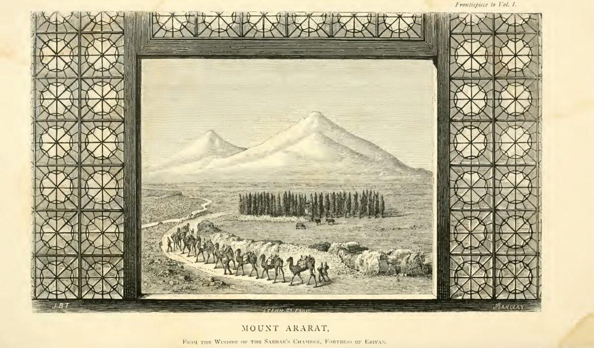
Choose the lens
Historical representations can reveal how travelers framed the mountain, but they must not be mistaken for photographic evidence. Modern field images provide topographic context without settling the Ark question.
Case Evolution / Ağrı Dağı
From Ararat to Masis
The history begins with a regional biblical name, not with the modern volcanic summit. ArkSearch separates references to Ararat/Urartu, early landing traditions in Corduene, and the later identification of the twin-peaked massif known to Armenians as Masis.
“Mountains of Ararat” is regional
Genesis 8:4 uses a plural expression. Ancient Ararat is normally connected with Urartu, a broad highland kingdom and region; the verse itself does not name the modern summit of Ağrı Dağı.
Other landing mountains remain active
Josephus preserves Armenian and Cordyaean traditions without identifying modern Masis. Jubilees names Mount Lubar. The Armenian history attributed to P‘awstos places Jacob of Nisibis’ Ark pilgrimage on Sararad in Korduk‘, south of Lake Van.
A singular “Mount Ararat” appears
Philostorgius explicitly calls a mountain in Armenia “the Mount of Ararat” on which Scripture says the Ark rested and reports relic traditions there. His accompanying geography does not securely identify that mountain with the modern Masis massif.
Masis becomes an explicit candidate
Medieval Armenian interpretation increasingly identifies Masis with the biblical landing place. A Genesis commentary attributed to Ełišē may preserve an earlier Masis identification, but its transmission requires caution; later Armenian authors explicitly argue for Masis.
The modern massif becomes unmistakable
Matthew Paris records Armenian visitors describing the Ark on two very high peaks. Soon afterward William of Rubruck describes two mountains called Massis, one higher than the other, with the Araxes at their feet, and locates the Ark tradition on the greater mountain.
The image becomes conventional
European maps, travel accounts and engravings increasingly pair Noah’s Ark with the distinctive twin-cone landscape. By the nineteenth century, Masis/Ağrı Dağı is the dominant Western “Mount Ararat,” setting the stage for expeditionary searches.
Document Test / Earliest Identification
What Is the First Link to Modern Mount Ararat?
There is no responsible single-date answer unless “Ararat” and “Masis” are first defined. The surviving texts give us several different historical thresholds.
Not a named summit
The biblical text says the Ark rested on the mountains of Ararat. That supplies a highland region, not a documentable identification of today’s Ağrı Dağı.
Philostorgius: “Mount of Ararat”
This is the earliest surviving text ArkSearch has located that explicitly says a singular Mount Ararat in Armenia was the mountain of the Ark. But he also makes the Euphrates rise there, so the passage cannot simply be projected onto modern Masis.
Concrete twin-peak geography
Matthew Paris records Armenian testimony of the Ark on two high peaks; William of Rubruck then names Massis, describes the greater and lesser mountains, and places the Araxes at their base. This is the earliest surviving evidence ArkSearch has found that is geographically unmistakable for the modern massif.
By Chardin’s Time, the Association Is Explicit
Jean Chardin’s published engraving labels the familiar twin-cone mountain visually with Noah’s Ark. It is not evidence for the Ark itself; it is evidence for how firmly the modern massif had entered European Ark geography by the seventeenth century.
Tradition Can Migrate
The story of Jacob of Nisibis is a useful example. P‘awstos places Jacob’s Ark pilgrimage in Korduk‘, but later Ararat tradition attached St. Jacob’s name to the monastery and spring on Masis. ArkSearch therefore dates a tradition by its surviving source rather than assuming every later shrine preserves the original geography.
Field Geography / Routes
How Searchers Moved Around the Mountain
The history of Ararat searching is partly a history of access. Climbers did not repeatedly inspect one fixed corridor: expeditions shifted among the northwestern Akhury side, Sardar Bulakh, Bayazid, the Ahora Gorge and the modern southern approach.
Akhury & St. Jacob / Northwest
Friedrich Parrot’s successful expedition began from the monastery of St. Jacob near the chasm of Akhury and reached the summit by the northwestern slope. Khachatur Abovian accompanied him. This became the foundational documented ascent.
Parrot–Abovian
Earthquake Changes the North Side
The catastrophic 1840 earthquake and mass movement destroyed Akhury/Arguri and the monastery of St. Jacob. Later searchers confronting the Ahora Gorge were working in a landscape physically altered after Parrot’s ascent.
Access break
Sardar Bulakh Becomes a Main Line
Hermann Abich, Khodzko and Khanikoff, James Bryce, Baker, Markoff, Postukhoff and H. F. B. Lynch are among the documented climbers who used Sardar Bulakh. Bryce’s 1876 timber story emerged from this broader ascent tradition.
Eastern / southeastern approaches
Bayazid Approaches
Robert Stuart’s 1856 ascent came from Bayazid, and later travelers also used approaches from this side. The route record shows why a reported “location on Ararat” is not useful unless slope, camp, glacier and elevation can be reconstructed.
Bayazid line
Glaciers, Gorge & Aerial Targets
Ark-search expeditions increasingly targeted specific glaciers, the Ahora Gorge, alleged eyewitness locations and aerial anomalies rather than simply the summit. Military restrictions and border security often dictated which sectors could actually be reached.
Search-sector era
Doğubayazıt–Topçatan–Eli
Ağrı’s governorate describes the frequently used southern climbing route through Doğubayazıt, Topçatan and Eli, with camps around 2,800 m and 4,200 m. That modern sanctioned route should not be confused with the historical search corridors on other faces.
South route
Evidence History / Claims Ledger
What Was Actually Found—or Not Found?
A famous story and a documented field result are not the same thing. This ledger records what can be tied to a source, what was testable, and where later investigation produced a negative or inconclusive result.
| Date | Search / claim | Documentary status |
|---|---|---|
| 1876 | James Bryce timber report. Bryce described finding a worked piece of wood at high elevation and later suggested it could satisfy an Ark interpretation. | The ascent and his own written account are documented; the wood lacks a secure archaeological context and reproducible recovery location. Testable claim / weak provenance |
| 1949 | Ararat anomaly photographed. U.S. aerial imagery captured an unusual feature near the summit that later became a major remote-sensing target. | The photograph is real government imagery. Identification of the feature as a constructed object was never established. Documented image |
| 1952 | French expedition: negative field result. Jean de Riquer, Fernand Navarra and their party searched multiple faces and the aerial target. | Contemporary reports say the supposed hull resolved into a crevasse and the apparent prow into basalt; the expedition reported no Ark remains. Documented negative result |
| 1955 / 1969 | Navarra wood recoveries. Navarra reported hand-hewn wood taken from glacial contexts; later teams recovered or circulated related samples. | Wood exists as a testable material claim, but published radiocarbon work placed tested material far too recently for a biblical Flood-era object and provenance remains disputed. Material tested / disputed context |
| 1970s–1980s | Creationist search programs. Teams associated with ICR and others repeatedly inspected glaciers, the western and northern sides and Ahora Gorge; astronaut James Irwin became one of the best-known expedition leaders. | Expeditions are well documented, but they did not produce independently verifiable Ark material. Search access often changed with Turkish security restrictions. Documented searches |
| 1990–1992 | CIA imagery review. Director Robert Gates asked the Office of Imagery Analysis to review imagery of the Ararat area. | A later CIA record says the review found “nothing conclusive,” only apparent rock formations protruding through snow and ice. Official inconclusive result |
| 2001 | Archaeological surface survey. ArcImaging and Atatürk University received Turkish permission for archaeological research on and around Ararat. | Security prevented surveying Korhan Pasture and Ahora Valley, while season and glacier danger prevented the planned high ice-cap stage. The completed work sampled surrounding archaeological sites rather than discovering an Ark structure. Permitted field survey / limited scope |
| 2010 | NAMI wooden-compartment claim. A Hong Kong–Turkish team publicized photographs of wooden spaces said to have been found above 4,000 m. | The exact site was withheld and no independently controlled excavation or reproducible archaeological context established the claim. It remains a disputed claimant report rather than a verified discovery. Unverified |
| 2026 | Current state of the peak search. The modern mountain remains an important search landscape, but current high-profile subsurface work in the region is centered at Durupınar rather than on the summit glaciers. | A 2026 peer-reviewed geoheritage review notes that numerous Ararat expeditions have not produced fully verifiable or reproducible Ark evidence. No reproducible identification |
Personnel File / Ağrı Dağı
People in the Ararat Search
The history is larger than twentieth-century Ark hunting. It begins with documented climbers and scientific travelers, then develops into targeted searches for timber, eyewitness locations, glaciers and aerial anomalies.
Open full personnel ledger6 documented searchers
Friedrich Parrot
Open field note
Parrot led the first recorded modern summit ascent. His published expedition is crucial because it preserves an actual route from St. Jacob/Akhury up the northwestern slope rather than a later Ark-search recollection.
Khachatur Abovian
Open field note
Abovian accompanied Parrot and belongs to the mountain’s foundational documented exploration history. His participation also anchors the ascent in the local Armenian intellectual world around Masis.
James Bryce
Open field note
Bryce climbed from Sardar Bulakh and published the timber episode that later became one of the most frequently repeated material claims. His own wording should remain the baseline for assessing it.
Fernand Navarra
Open field note
Navarra joined the documented 1952 French search, which reported a negative result, and later became famous for separate wood-recovery claims in 1955 and 1969. Those later samples are part of the laboratory-testing record.
Jean de Riquer
Open field note
De Riquer led the 1952 French expedition with Navarra. Contemporary reporting is unusually valuable because it records both the intended glacier search and the expedition’s negative identification of the aerial “hull” target.
James Irwin
Open field note
The Apollo 15 astronaut led repeated searches in the early 1980s and helped bring modern aerial reconnaissance and international media attention to Ararat. His expeditions did not produce independently verified Ark remains.
Archive Desk / Source Dossier
Documents Behind the Ararat Story
This dossier now works backward from later claims to the documents that can actually be opened, dated and compared. Sources that say “Ararat” are kept separate from sources that identify Masis/Ağrı Dağı.
Open full source dossierPrimary and historical source record
Josephus & the Cordyaean Tradition
Josephus says the Ark came to rest on a mountain in Armenia, then quotes Berossus on remains in the mountains of the Cordyaeans. This is evidence for an early Armenian/highland Ark geography, not a secure identification of the modern Ararat massif.
P‘awstos: Jacob in Korduk‘
The Armenian history attributed to P‘awstos places Jacob of Nisibis’ Ark pilgrimage on Sararad mountain in the district of Korduk‘. It is a primary reason not to retroject the later St. Jacob-on-Masis tradition into every early Armenian account.
Philostorgius: A Singular Mount Ararat
Philostorgius explicitly describes a Mount Ararat in Armenia as the mountain on which Scripture says the Ark rested and reports preserved wood and nails. Yet his river geography does not securely match modern Masis.
Matthew Paris & William of Rubruck
Matthew Paris records Armenian visitors describing the Ark on two high summits; Rubruck describes two mountains called Massis with the Araxes below and the Ark tradition attached to the greater peak. Together they make the modern twin-cone massif geographically recognizable.
Published Ascent & Route Record
Parrot’s expedition and later climbers transformed inherited sacred geography into a documented mountain environment. H. F. B. Lynch preserved a useful list of successful ascents and their starting sides, including St. Jacob/Akhury, Sardar Bulakh and Bayazid.
Contemporary French Expedition Reports
Le Monde followed the de Riquer–Navarra expedition while it was on the mountain. The reports document a serious glacier search and, importantly, a negative result: the aerial “hull” was identified as a crevasse and the supposed prow as basalt.
CIA Imagery Review
A declassified CIA record says former Director Robert Gates ordered the Office of Imagery Analysis to review imagery of Mount Ararat collected between November 1990 and January 1992. The recorded conclusion was “nothing conclusive,” with apparent rock formations protruding through snow and ice.
Mount Ararat Archaeological Surface Survey
Atatürk University and ArcImaging received Turkish permission for archaeological research on and around Ararat. Security prevented access to Korhan Pasture and Ahora Valley, while the late season made the planned glacier stage unsafe, so the completed work concentrated on surrounding archaeological sites and samples.
Official Route & Modern Context
Ağrı’s governorate describes present climbing access through Doğubayazıt–Topçatan–Eli and the commonly used south route. A 2026 peer-reviewed geoheritage review summarizes the mountain’s search history and notes that reported Ark expeditions have not yielded fully verifiable or reproducible evidence.
ArkSearch Assessment
What the Ararat Case Can—and Cannot—Establish
Assessment
Ağrı Dağı has an exceptionally important modern search history and a substantial documentary trail of expeditions, witnesses, material claims and imagery. That record establishes the history of the search; it does not yet establish the identification of a surviving Ark. The decisive gap remains secure provenance tied to a reproducible physical location and independently testable material context.
Dossier Navigator / Interactive
Work the Case File
Move between the major evidence categories without losing the distinction between what is observed and what is inferred.
How old is the Ağrı Dağı identification?
Genesis names the “mountains of Ararat,” not Masis. Early Ark geography includes Corduene/Korduk‘ and Lubar. Philostorgius gives an early singular Mount Ararat, while the surviving record becomes geographically unmistakable for the modern twin-peaked Masis in the medieval Armenian tradition and the thirteenth-century accounts of Matthew Paris and William of Rubruck.
Who actually searched the mountain?
Modern searches range from scientific ascents to missionary parties, eyewitness-follow-up expeditions, film projects and remote reconnaissance. Each expedition file records route, objective, participants, claimed finds and what was independently documented.
What about alleged wood?
Material claims are potentially strong only when recovery location, chain of custody, identification and dating can all be established. A sample without secure provenance cannot by itself identify an archaeological structure.
What can photographs prove?
Aerial and satellite images are useful for relocating features, comparing seasonal exposure and testing whether an anomaly persists across viewpoints. Shape alone is not enough to identify a structure.
Continue the Investigation
Follow the Ararat Case
Expedition Ledger
Trace who climbed, searched, filmed, sampled and reported—and what each expedition actually documented.
→
The Searchers
Open the files on Bryce, Navarra, eyewitness claimants and later researchers.
→
Evidence Desk
Compare wood, testimony and imagery claims by evidence class.
→