
Durupınar
A boat-shaped formation south of Mount Ararat that has generated decades of claims, geological debate and—now—renewed geophysical work, sampling and core drilling.
The case
A Shape That Demands Testing
In this dossier
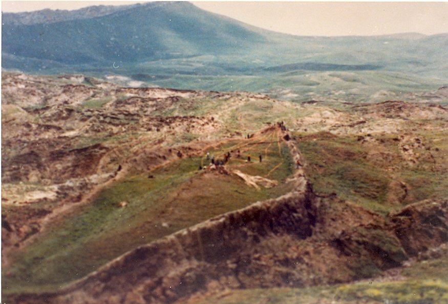
Durupınar is visually compelling, which is both its strength and its danger. A ship-like outline can generate hypotheses, but geometry alone cannot identify a buried vessel. The strongest path forward is direct testing of the material and structures beneath the surface.
Why the new drilling matters
Core drilling can directly test whether radar reflectors correspond to natural bedding, fractures, lithologic boundaries, cavities or constructed materials. If claims of timber or architectural boundaries are correct, recoverable material should allow laboratory testing.
Natural geological model
ArkSearch gives the natural-origin hypothesis the same visual clarity as the vessel hypothesis, including structural geology, bedding relationships, erosion, competent ridges and proposed synclinal explanations. A geological explanation must fit the actual subsurface geometry, not merely provide a label.
What would change the debate?
Repeated worked materials, consistent construction patterns, clear biological wood structure, joinery, archaeological context or independently replicated artificial boundaries would be significant. Conversely, continuous natural strata and mineralogy matching local geology would weigh strongly toward a natural formation.
Field Image Board / Interactive
Read the Formation From More Than One View
A single overhead photograph can make Durupınar look deceptively simple. Move between historical, close-range and regional views to keep the surrounding geology in the frame.
Case Evolution / Durupınar
From Aerial Photograph to Core Drill
Durupınar’s modern history is unusually well documented. A visible landform noticed in 1959 became an Ark claim, was rejected by the first expedition, revived in the late 1970s, tested with geophysics and cores in the 1980s, reinterpreted geologically in the 1990s and 2000s, and returned to direct subsurface testing in 2026.
İlhan Durupınar sees the outline
While reviewing aerial photographs for Turkey’s General Directorate of Mapping, Captain İlhan Durupınar noticed an anomalous boat-shaped feature near Üzengili. The Turkish mapping authority preserves both his photograph and the contemporary September 1959 newspaper coverage.
The first expedition tests the claim
An Archeological Research Foundation team reached the formation, dug and blasted into it, and after a brief investigation reported no visible archaeological remains and judged the feature natural. LIFE nevertheless made the site internationally famous on September 5, 1960.
Ron Wyatt revives the site
Wyatt began promoting Durupınar as the Ark and returned after the 1978 earthquake exposed a long crack. His 1979 samples generated chemical analyses that later became central to “petrified wood” arguments even though the laboratory itself did not identify the material as wood.
Fasold, Baumgardner and Bayraktutan instrument the site
Metal detection, GPR, magnetometry, seismic work and four core holes moved the debate beyond surface shape. The 1988 cores recovered no identified wood; two reportedly entered layered ophiolitic bedrock at roughly five metres.
A leading advocate changes position
David Fasold, once one of the site’s best-known advocates, came to reject the Ark interpretation. With geologist Lorence Collins he published a 1996 peer-reviewed paper explaining the formation as a natural doubly plunging syncline with weathered volcanic and sedimentary materials.
The Telçeker earthflow model is published
Turkish engineering geologist Murat Avcı proposed a different natural mechanism: a resistant Miocene limestone block slumped over weaker clay and was modified by earthflow, meltwater, abrasion and dissolution into the ship-like form.
Modern imaging and soil chemistry reopen the case
Electrical resistivity, GPR, LiDAR, photogrammetry and later soil testing produced new anomalies and chemical differences. Advocates interpreted some linear responses as architectural features; critics argued the signals remained compatible with complex geology and environmental differences.
Authorized drilling puts interpretations at risk
A Sivas Cumhuriyet University-led project received official permission for mapping, new radar, soil sampling and dry core drilling. Laboratory analysis continues into 2027, making this the most important direct-test phase since the 1988 cores.
Document Test / Discovery Record
What Can We Actually Document?
The best Durupınar history begins with records that can be dated, opened and compared. Later stories about a shepherd seeing the formation in 1948 may be relevant, but the securely documented modern discovery begins in September 1959.
Turkish Mapping Archive
Turkey’s General Directorate of Mapping records that İlhan Durupınar noticed the structure on September 11 while working through aerial photographs. A September 18 Milliyet report announced the find, and the official history reproduces both Durupınar examining the photograph and the first aerial image.
LIFE: “Noah’s Ark?”
LIFE published the aerial photograph and the field expedition under the headline “Noah’s Ark? Boatlike form is seen near Ararat.” The article is historically important because it preserves the site before decades of later interpretation and records the first expedition’s negative result.
Protected Site—Not a Scientific Verdict
Turkey’s High Council registered the area under decision 3657 as a protected cultural and natural property/open-air museum. The designation protects and promotes the site; it should not be described as a government scientific determination that the formation is Noah’s Ark.
Field Record / Testing History
What Has Actually Been Tested?
Durupınar has been tested repeatedly, but different generations used very different methods. The useful question is not how many investigations occurred; it is what each method could actually establish.
Open complete testing history1979–2026 methods and results
Galbraith chemistry
Wyatt submitted an interior sample and an exterior control to Galbraith Laboratories. The interior sample had more total carbon, calcium oxide and potassium, among other differences. The certificates reported chemistry; they did not identify petrified wood or organic timber.
Chemical analysis
Metal detection and geophysics
Wyatt and Fasold reported regular metallic patterns and radar responses. A broader 1987 Atatürk University/Los Alamos study used 71 GPR transects plus magnetometry and seismic work. It detected subsurface reflectors but did not establish a wooden ship.
GPR • magnetics • seismic
Four core holes
Baumgardner and Bayraktutan’s drilling is especially important because it sampled material directly. No wood was identified in the cores; two holes reportedly transitioned from mudflow material into layered ophiolitic rock at about 5 m depth.
Direct subsurface sampling
Collins–Fasold reassessment
Microscopy and structural geology were used to re-evaluate “iron brackets,” “walls,” “bark” and anchor stones. Collins and Fasold interpreted them as weathered minerals, natural limonite/magnetite concentrations, metamorphosed peridotite and local andesite.
Peer-reviewed geology
Avcı earthflow model
Avcı placed the formation inside the larger Telçeker mass-movement system and modeled the boat-like feature as a resistant limestone block transported and reshaped by slope processes, earthflow, glacial melt and dissolution.
Engineering geology
ERT, GPR, LiDAR and photogrammetry
New surveys mapped resistivity contrasts and radar reflectors at much higher spatial resolution. Some features were described publicly as walls, corridors or decks; those architectural labels remain interpretations until drilled or excavated targets identify corresponding material.
Modern remote sensing
Soil comparison
William Crabtree’s reported 88-sample comparison found higher organic matter and potassium and lower pH inside the formation. The chemical differences are observations; whether they reflect decayed wood, vegetation, soil depth, drainage, carbonate or another process remains testable.
Soil chemistry
Deep drilling and new radar
The university-led season drilled 12 holes inside and four outside the formation, in places approaching 20 m, and collected hundreds of samples. As of October 31, laboratory dating, material identification and final radar analysis were still pending.
Current ground truth
Evidence History / Claims Ledger
Observation, Claim, or Test Result?
Durupınar has generated some of the Ark search’s most memorable claims. This ledger records what is actually observed and what still depends on interpretation.
| Date | Claim / record | Assessment |
|---|---|---|
| 1959 | Boat-shaped aerial outline. İlhan Durupınar recognized an unusually symmetrical landform in aerial survey imagery. | The shape is real and documented. Shape alone cannot distinguish a vessel from a natural landform. Documented observation |
| 1960 | First ground expedition. Investigators dug and blasted portions of the site and reported no visible archaeological remains. | A genuine negative field result, although the investigation was brief and lacked the later geophysical methods available today. Documented negative result |
| 1979 | Higher carbon interpreted as wood. Galbraith sample No. 2 from inside the formation contained more total carbon than the exterior control. | The laboratory measured chemistry but did not identify wood. Carbonate-rich geology can also contribute total carbon; organic and inorganic carbon were not separated in those certificates. Real data / interpretation disputed |
| 1980s | Metal “ribs,” brackets and structural lines. Wyatt and Fasold interpreted detector responses and mineral concentrations architecturally. | Later geological work attributed the supposed metal features to natural iron-bearing minerals and weathering; the claimed structural pattern has not been archaeologically demonstrated. Claim not established |
| 1987 | Radar structure. Joint geophysics mapped prominent reflectors including a broad planar/V-shaped response. | The subsurface contrasts are real measurements; a reflector is not itself proof of a hull, wall or deck. Instrument records remain valuable targets for comparison with later surveys and cores. Measured anomaly |
| 1988 | Core drilling. Four boreholes sampled the formation. | No identified wood was recovered. Two holes reportedly encountered layered ophiolitic rock at roughly 5 m, providing direct evidence that must be reconciled with newer “no bedrock” interpretations. Direct physical test |
| 1996 / 2007 | Natural geological models. Collins–Fasold and Avcı proposed different geological mechanisms for the boat-like geometry. | Both models are published and testable. They disagree in details but demonstrate that natural explanations make specific predictions about bedding, lithology, fractures and slope movement. Published alternative models |
| 2019–2024 | Walls, rooms, decks and organic-rich soil. Modern scans and soil work generated new architectural and decayed-timber interpretations. | Linear/angular anomalies and soil differences are observations. Assigning them architectural or wooden origins requires independent analysis and physical confirmation at predicted coordinates and depths. Promising targets / unconfirmed identity |
| 2026 | No bedrock in the new boreholes. Andrew Jones reports that 12 interior and four control holes did not encounter the continuous bedrock expected by some models. | Important new field information, but final logs, coordinates, lithologic descriptions and laboratory results need publication before the result can be weighed against the 1988 cores and published geological models. Preliminary field result |
| Oct. 2026 | Burnt/charred wood fragments sent for testing. Project director Cenker Atila reported small burnt-wood material sent for species identification and radiocarbon work. | As of October 31, no published species identification, radiocarbon result or full provenience report establishes the material’s age or relationship to a vessel. Atila has publicly urged caution while results are pending. Laboratory result pending |
Researcher File / Nate Loper
Testing Durupınar Without Prejudging the Answer
Nate Loper’s 2026 work evaluates Durupınar from within a young-earth, global-Flood framework while arguing that belief in Noah and the Ark does not require accepting a particular site before the evidence establishes it.
Reassessing the Durupınar Formation
Published October 20, 2026 in Answers Research Journal 19:195–204, Loper’s paper evaluates recent GPR, ERT, LiDAR, soil chemistry, historical lab data and the new drilling program.
His current conclusion is cautious: the reported anomalies are worth testing, but none yet requires an artificial vessel interpretation. He argues that the strongest way to investigate the site is to pre-register what each hypothesis predicts and then use the cores and laboratory work to decide between them.
Loper also emphasizes the importance of the older record: the 1979 chemistry did not identify wood; the 1988 cores recovered no identified wood and reportedly entered ophiolitic bedrock; and both published natural models and current Ark interpretations should be tested against the same physical data.
Observation Is Not Identification
A radar reflector can be real without being a wall. A cavity can be real without being a room. Higher carbon can be real without coming from timber. A hard layer can break a drill bit without being petrified wood. The next step is physical identification, not a stronger label.
Keep Drilling
Loper does not argue that Durupınar should be abandoned. He supports the current drilling precisely because direct samples can resolve questions that imagery alone cannot. If predicted “walls” yield worked or mineral-replaced wood, the natural-only model weakens. If they yield continuous natural strata, the architectural interpretation should weaken.
Personnel File / Durupınar
People in the Durupınar Research
Durupınar’s research history is unusually revealing because several prominent investigators changed position as new evidence appeared. Inclusion here records contribution, not endorsement.
Open full personnel ledger10 documented researchers
İlhan Durupınar
Open field note
Durupınar noticed the formation on September 11, 1959 while reviewing aerial photographs for Turkey’s General Directorate of Mapping. His observation is the secure beginning of the modern site history.
Ron Wyatt
Open field note
Wyatt revived interest in Durupınar and promoted interpretations involving metal ribs, petrified timber, chemical evidence and radar structure. His work shaped the modern Ark claim even where later investigators disputed the interpretation.
David Fasold
Open field note
Fasold became one of Durupınar’s most visible advocates, then changed his assessment after further geological study. In 1996 he coauthored the peer-reviewed Collins–Fasold paper arguing that the formation is natural.
John Baumgardner
Open field note
Baumgardner co-led the 1987 geophysical investigation and participated in the 1988 core program. His later report treated important parts of the site as explainable by clay and rock debris flowing around an isolated block.
M. Salih Bayraktutan
Open field note
Bayraktutan was central to the Turkish scientific investigation, coauthoring the 1987 geophysical report and participating in later drilling. His field observations and core descriptions are essential to reconstructing the older subsurface record.
Lorence G. Collins
Open field note
Collins examined the claimed metal, wood and structural evidence and coauthored the 1996 Journal of Geoscience Education paper with Fasold, interpreting Durupınar as a natural geologic structure.
Murat Avcı
Open field note
Avcı published a natural model connecting the formation with the Telçeker earthflow, a displaced limestone block, weak clay units, abrasion, meltwater and dissolution.
Andrew Jones
Open field note
Jones has coordinated modern GPR, ERT, LiDAR, photogrammetry, soil testing and the current international research program. In 2026 he helped secure the shift from non-invasive work to permitted core drilling.
Cenker Atila
Open field note
Atila leads the officially authorized 2026 project. He has publicly described corridor- and room-like radar features while repeatedly cautioning that geological explanations remain possible and laboratory results are still pending.
Nate Loper
Open field note
Loper published a peer-reviewed reassessment of recent Durupınar claims in October 2026. He affirms the historical Flood and Ark but concludes that the site’s current evidence remains compatible with natural geology and should be resolved through harder physical testing rather than stronger publicity.
Archive Desk / Source Dossier
Documents Behind the Durupınar Case
The site has enough surviving documentation to reconstruct its history without relying on later retellings. ArkSearch prioritizes contemporary records, published geology, original geophysics and direct physical sampling.
Open full source dossierPrimary, technical, and current records
General Directorate of Mapping Record
Turkey’s official mapping history records İlhan Durupınar’s September 11 discovery while examining aerial photographs and reproduces the September 18 newspaper report and the early aerial image.
LIFE and the First Expedition
The September 5, 1960 issue of LIFE preserves the aerial photograph and the first ground investigation. The team’s press account reported no visible archaeological remains and characterized the formation as natural after a short field visit.
Galbraith Laboratory Certificates
Wyatt’s interior and exterior samples were chemically analyzed by Galbraith Laboratories. The reports record total carbon and oxide chemistry. They do not identify wood, petrified wood or organic carbon. Loper’s 2026 paper republishes and compares the values.
Bayraktutan–Baumgardner Geophysics
The joint Atatürk University/Los Alamos investigation used 71 GPR transects, magnetometry and seismic methods. The original report remains valuable because it preserves survey geometry and the actual anomalies before decades of later overlays and publicity.
Core Drilling Record
Four core holes provide an older direct-sampling baseline. Baumgardner’s report says no wood was identified and records transitions into layered ophiolitic material in two holes at roughly five metres.
Collins & Fasold — Peer-Reviewed Reassessment
The Journal of Geoscience Education paper tests specific claimed artifacts and structures and interprets the formation as a natural doubly plunging syncline. Fasold’s authorship is historically significant because he had previously promoted the site as the Ark.
Murat Avcı — Telçeker Earthflow
Published in the Bulletin of Engineering Geology and the Environment, Avcı’s model treats the formation as a displaced limestone block modified by mass movement, abrasion and dissolution.
Modern GPR / ERT / LiDAR Reports
Noah’s Ark Scans maintains the modern survey reports, including 2014 resistivity work, 2019 GPR and the 2023 synthesis by Andrew Jones. These are the primary documents for evaluating the current architectural interpretations rather than relying on media graphics.
Sivas Cumhuriyet University Project
The officially permitted 2026 program began fieldwork in late June with about 20 researchers and students from five countries. It established a grid, mapped the formation, ran new radar, collected soil samples and performed dry percussion core drilling. Laboratory analysis and reporting continue into 2027.
Loper — Reassessing the Formation
Nate Loper’s peer-reviewed paper evaluates recent radar, soil, drilling and historical laboratory claims from within a young-earth/global-Flood framework. It argues for harder falsifiable testing rather than assuming that either theological commitment or skepticism settles the site.
Pending 2026 Laboratory Results
By late October the team reported small burnt/charred wood fragments sent for species identification and radiocarbon dating, while radar processing and soil/core analysis remained incomplete. Project director Cenker Atila has publicly cautioned that geological explanations remain possible.
ArkSearch Assessment
What the Durupınar Case Can—and Cannot—Establish
Assessment
Durupınar is one of the most testable Ark claims because the disputed object is accessible, mapped and now being drilled. Its boat-shaped outline, repeatable geophysical contrasts and measurable soil differences are legitimate observations. The historical record also contains substantial contrary evidence: the first expedition reported no archaeology, 1988 cores recovered no identified wood, Fasold later rejected the Ark interpretation, and multiple published geological models explain the landform naturally. The 2026 program is valuable precisely because it can force those competing interpretations into contact with physical samples.
Dossier Navigator / Interactive
Work the Case File
Move between the major evidence categories without losing the distinction between what is observed and what is inferred.
Start with the visible formation
The boat-like outline is an observation, not a conclusion. ArkSearch treats planform geometry as the starting hypothesis and asks which natural or artificial processes could generate the full three-dimensional structure.
Test the natural model
Bedding, folding, erosion, competent ridges, fractures and local lithology must be mapped as a connected system. A natural explanation has to account for the actual angles and continuity of the site, not simply call it a geological formation.
Translate anomalies carefully
GPR and electrical surveys measure contrasts in physical properties. They can identify boundaries worth testing, but they do not independently label those boundaries as walls, decks or timber.
Put the interpretation at risk
Core drilling is valuable because it can sample specific targets beneath the surface. Results can support or falsify proposed structural interpretations rather than leaving the debate at the level of surface resemblance.
Continue the Investigation
Follow the Durupınar Case
Current Field Desk
Follow the 2026 cores, laboratory work, radar interpretation and the next testing window.
→
Evidence & Claims
Separate measurable anomalies from the structural interpretations attached to them.
→
Research Library
Open official project records, critical papers and technical source files.
→